
Hey everyone, i am wondering if anyone could fill me in on Cache creek WA and the surrounding BLM land? its fairly close to my house and id like to try it out for some squirrel and rabit hunting. Im still new to the area and to hunting so any info / advice would be very helpfull, thanks in advance - Eric
Navigation
Install the app
More options
You are using an out of date browser. It may not display this or other websites correctly.
You should upgrade or use an alternative browser.
You should upgrade or use an alternative browser.
- Thread starter johndoe
- Start date
tony270
Well-known member
- Joined
- Oct 2, 2003
- Messages
- 1,461
- Reaction score
- 71
Cedar Roughs, the old access point on Pope Creek Road. If you look on a BLM map you can see where the BLM land crosses Pope Creek Road the road. Cross the creek and the hillside is full or tree squirrels. Use Google maps (not Google earth) and search using this address 38.631267,-122.33411 That's the address to the old trailhead, use the Google street view option to see the turnout for parking.<?xml:namespace prefix = o ns = "urn:schemas-microsoft-com<img src=" /><o ></o>
></o>
></o>tony270
Well-known member
- Joined
- Oct 2, 2003
- Messages
- 1,461
- Reaction score
- 71
If you are in tip top shape and want to go to Cache Creek to hunt tree squirrels. I know of several places there too. You can find lots os tree squirrels along Cache Creek. The easiest place to find them is along the creek in the area that I’m about to post. The squirrels hang out in the tall pines that run along the creek, lots of catfish, turkey, bear, and hard to hunt deer.
Use Google maps, not Google earth to search this address;
38.977527,-122.500563
tony270
Well-known member
- Joined
- Oct 2, 2003
- Messages
- 1,461
- Reaction score
- 71
Use this to tool to finds BLM land, use the scroll wheel to zoom in to the California area of intrest.
GeoCommunicator
GeoCommunicator
so i headed up to Cedar Roughs this morning ( 0600 - 1300 )for some tree squirrel / rabit hunting, and unfortunately i didnt see a single 1. I did however see some quial, a couple pigs, even a deer, but no squirrels. The day was not wasted however, the hiking was great and the exercise was nice, im thinking about heading to sonora for my next tree squirrel hunt, anyone know any lucky spots out there?
tony270
Well-known member
- Joined
- Oct 2, 2003
- Messages
- 1,461
- Reaction score
- 71
so i headed up to Cedar Roughs this morning ( 0600 - 1300 )for some tree squirrel / rabit hunting, and unfortunately i didnt see a single 1. I did however see some quial, a couple pigs, even a deer, but no squirrels. The day was not wasted however, the hiking was great and the exercise was nice, im thinking about heading to sonora for my next tree squirrel hunt, anyone know any lucky spots out there?
At least you saw some game. Anyway, the best way to get those squirrels is get on the hillside before daybreak. Sit and be real quiet and you’ll hear them start barking and or see them when they start moving, squirrels are most active in the early morning. If you choose to walk all the way to the top, use the walk, stop, and listen method, using that method it’s likely that you bust them crossing the trail or off to the side.
But in that area the easiest squirrels to hunt are the ones closest to the creek. Find the old trail and go up 25 to 35 yards, hunt to the right side and find a spot to sit. A spot that offers the best view, one that has visible signs of squirrel activity such as cut acorns and or cones. The scrub oaks in that area have a low canopy, and the land on that hillside is steep. With that in mind you’ll need to hunt them a little differently than the squirrels that are found in an open pine or oak forest habitat. <?xml:namespace prefix = o ns = "urn:schemas-microsoft-com
></o>Now you see why I don't have an issue posting that location, lol. You got to have a set to hunt that area. That's why they still have game there. There are a lot of squirrels in that area, you just have to be patient and start out before daylight. Put in the time to learn an area, and then you will start to bag game, that's one key to hunting, learning the aera. Resist trying to learn too many areas at the same time. <o
></o><o
></o>
Last edited:
I think im going to take your advice Tony270 and give that spot another chance, this time ill get there before sunrise and get me a good spot, at least next time ill know the area better. I have a couple questions about the access point, i found the old gate that led to the trail it was all open and i didnt have to jump any fences, the trail led me to a good crossing point on the river and i had no trouble making my way up the hill side. My question and concern is i found another gate not far up the road that had no firearms and no hunting signs posted, i later found that the trail from that gate led right into the trail i was on. I looked up on BLM website cedar roughs and it said access was from a brown and yellow gate, that was the same gate that had those signs, i tryed calling the ukiah field office to ask them about it but i got no answer. Just curious if you knew anything about that. Also i was curious about the Maxwell creek access area, is that any good for the squirrels? Thanks for all the help -Eric
tony270
Well-known member
- Joined
- Oct 2, 2003
- Messages
- 1,461
- Reaction score
- 71
Sorry for not getting back sooner.
You seem to have found the New Access point to Cedar Roughs that the CDFG established. The only problem with that access points is that it is actually controlled by BLR (The Bureau of Land Reclamation). BLR is the US Government agency that administers Lake Berryessia and much of the land around it. Also, Government workers and locals have been known to post illegal signage like that to keep hunter at bay.
The best thing to do is call DFG and ask to speak with Chamois Andersen, and call back to the Ukiah BLM and ask to speak to the Biologist that works the Cedar Roughs and Maxwell areas, and call the Bureau of Land Reclamation Lake Berryessa Supervisor and ask him/she, don’t ask a clerk, Ranger or CDFG Warden.
Back when I hunted Cedar Roughs the rule of thumb was that a hunter could legally cross BLR land to get to BLM land with an unloaded shouldered rifle or in a boat too. I was checked by a CDFG Warden once as I was leaving that very spot, he was hiding in the bushes as I approached the parking area. I showed him my maps and at the time they had no signs stating no weapons.
The best thing to do if you can’t find an answer is to use the old access point. It had a water metering station off to the side of the road. It measured/measures the high water mark in Pope Creek during high water events. The station resembled/resembles a vertical corrugated sheet metal culvert. If you park in that turnout directly across the creek is an old trial, it may be difficult to find but if you climb 20 yards of so away from the creek you should be able to pick it up. It is a difficult trail with switchbacks all the way to the top. I left several Indian arrowheads on that hillside, all of them made out of black obsidian.
I’m going to try and hook you up with the details on the old Cedar Roughs access point that crosses Pope Canyon Road. The BLM land that crosses Pope Canyon Road and Pope Creek is not designated as Wilderness. It’s just plain old BLM land.
http://www.dfg.ca.gov/lands/articles/cedarroughs01.html
fficeffice" /><?xml:namespace prefix = o ns = "urn:schemas-microsoft-com
 http://www.blm.gov/pgdata/etc/medialib/blm/ca/pdf/pdfs/ukiah_pdfs.Par.81174.File.dat/cedarroughs_wilderness.pdf
<o></o>As for the Maxwell Unit, I know deer are harvested every year from that unit. When I hunted the area the Maxwell unit was well logged and not a good place to hunt tree squirrels. According to the information on the CDFG website the Maxwell Unit is accessed via the quote below;
></o>
<o></o>
You seem to have found the New Access point to Cedar Roughs that the CDFG established. The only problem with that access points is that it is actually controlled by BLR (The Bureau of Land Reclamation). BLR is the US Government agency that administers Lake Berryessia and much of the land around it. Also, Government workers and locals have been known to post illegal signage like that to keep hunter at bay.
The best thing to do is call DFG and ask to speak with Chamois Andersen, and call back to the Ukiah BLM and ask to speak to the Biologist that works the Cedar Roughs and Maxwell areas, and call the Bureau of Land Reclamation Lake Berryessa Supervisor and ask him/she, don’t ask a clerk, Ranger or CDFG Warden.
Back when I hunted Cedar Roughs the rule of thumb was that a hunter could legally cross BLR land to get to BLM land with an unloaded shouldered rifle or in a boat too. I was checked by a CDFG Warden once as I was leaving that very spot, he was hiding in the bushes as I approached the parking area. I showed him my maps and at the time they had no signs stating no weapons.
The best thing to do if you can’t find an answer is to use the old access point. It had a water metering station off to the side of the road. It measured/measures the high water mark in Pope Creek during high water events. The station resembled/resembles a vertical corrugated sheet metal culvert. If you park in that turnout directly across the creek is an old trial, it may be difficult to find but if you climb 20 yards of so away from the creek you should be able to pick it up. It is a difficult trail with switchbacks all the way to the top. I left several Indian arrowheads on that hillside, all of them made out of black obsidian.
I’m going to try and hook you up with the details on the old Cedar Roughs access point that crosses Pope Canyon Road. The BLM land that crosses Pope Canyon Road and Pope Creek is not designated as Wilderness. It’s just plain old BLM land.
http://www.dfg.ca.gov/lands/articles/cedarroughs01.html
ffice
ffice" /><?xml:namespace prefix = o ns = "urn:schemas-microsoft-com
<o
></o>As for the Maxwell Unit, I know deer are harvested every year from that unit. When I hunted the area the Maxwell unit was well logged and not a good place to hunt tree squirrels. According to the information on the CDFG website the Maxwell Unit is accessed via the quote below;How to get there and what to do.<o
<oDirections: Off Pope Canyon Road 4.2 miles west of Pope Creek bridge, Lake Berryessa, or 5.6 miles east of Pope Valley airstrip. Provides access to 175 acres of DFG and 160 acres of BLM lands adjacent to Maxwell Creek and access via abandoned Dollarhide Road. After approximately one mile, trail ends at private land.<o
Activities: Hiking, hunting, fishing, camping and wildlife viewing. The BLM is working to develop trails and a parking lot.<o
Camping: Though there is no camping on the DFG land, and no drinking water or restroom facilities, primitive camping is allowed on BLM land but fire permits are required.<o
For more information, contact:
Bureau of Land Management: (707) 468-4000
Bureau of Reclamation . Lake Berryessa Recreation Office: (707) 966-2111
California Dept. of Fish and Game, Central Coast Region: (707) 944-5500
></o><o
></o>Attachments
Last edited:
My understanding now is, you have to go to BLR and get a permit to have a gun on their property. Even going into the Ceder R. area. I asked a game warden about this just last week. Not sure how accurate it is, but might check into it.
tony270
Well-known member
- Joined
- Oct 2, 2003
- Messages
- 1,461
- Reaction score
- 71
My understanding now is, you have to go to BLR and get a permit to have a gun on their property. Even going into the Ceder R. area. I asked a game warden about this just last week. Not sure how accurate it is, but might check into it.
Hi airman.ffice
ffice" /><?xml:namespace prefix = o ns = "urn:schemas-microsoft-com<img src=" /><o></o>My understanding is that a permit is needed to carrying a weapon in a boat while on BLR administered property, not on foot. When I hunted Cedar Roughs it was one of the areas that CDFG Biologist Jim Swanson was responsible for. <o
></o><o
></o>In my opinion what happened is the CDFG wanted its hands in the access to Cedar Roughs, and forever and a day locals have been all butt hurt because the public has access to prime hunting property that they feel is theirs. So the state decided to purchase some property to enable easier access.
<o
></o>Anyway, the old access is a bear to hike, and many of the locals dispute the access even though the land is clearly BLM.
So the state went on and pruchased the land, but the only problem with that is the new access is using the old parking area that BLR had set aside for hikers.
Back them all of us hard charging hunters knew that we could cross BLR land with unloaded shoulder weapons to get to BLM land. And I don’t’ see any reason why we can’t cross BLR land today being that we can have unloaded weapons in National Parks now that the 2<SUP>nd</SUP> amendment has been reestablished. <o
></o><o
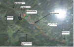
></o>The spot that I have marked on the map “new access” is the old BLR hiking access. I’ll post some clearer photos so anyone can find the old access trail. If you really want to be stealthy park at the new BLR/CDFG access and hike back down Pope Caynon Road and enter at the old BLM access, then nobody will where you are.
I'll post the maps in a few.
Last edited:
tony270
Well-known member
- Joined
- Oct 2, 2003
- Messages
- 1,461
- Reaction score
- 71
</SPAN>
</SPAN>
<?xml:namespace prefix = o ns = "urn:schemas-microsoft-com
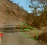
 In the second photo I forgot to point out the new parking area, it's the same area that I wrote that "I think you parked here". The red trail is the route I think you took, that's not the way to go. <o></o></SPAN>
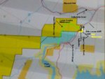
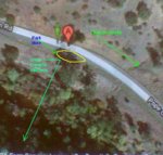
I've also depicted on the second map a Guardrail Landmark to help find the old parking access area; the yellow trail mark is an estimate of its location.<o></o>
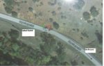
All of my superimposed marking on these maps are estimates, except for that the old BLM access point is accurate and correct, park there or hike from the new parking area. You can also park in the new location and hike in to BLM land, just don’t shoot on BLR land and bring your own maps. And when you look on the Color Coded BLM map the Blue land is the land CDFG purchased.
I don't know what people are saying, but this area has been settled under litigation and is solidly BLM Public land and has more than one legal access and is legal to hunt.<o></o>
</SPAN>
</SPAN>
<?xml:namespace prefix = o ns = "urn:schemas-microsoft-com
></o></SPAN>I've also depicted on the second map a Guardrail Landmark to help find the old parking access area; the yellow trail mark is an estimate of its location.<o
></o>All of my superimposed marking on these maps are estimates, except for that the old BLM access point is accurate and correct, park there or hike from the new parking area. You can also park in the new location and hike in to BLM land, just don’t shoot on BLR land and bring your own maps. And when you look on the Color Coded BLM map the Blue land is the land CDFG purchased.
I don't know what people are saying, but this area has been settled under litigation and is solidly BLM Public land and has more than one legal access and is legal to hunt.<o
></o></SPAN>
Last edited:
QRCode
