I picked up my boy from San Jose State on Friday at noon, and we hunted Liggett on Saturday morning during a break in the weather. It had rained all night, so any tracks we saw were fresh. There were absolutely no tracks in the old section of Training Area 30. That was quite a change from a few years back when the whole area was rooted, and there were tracks everywhere. Maybe someone else has something to add?
Richard
Forgot to mention that I will be there this weekend and next also.
I did not get the chance to hunt but I did swing by there on Monday. This place has my interest. I'm looking at getting a tag just to goto this place and camp. I was impressed and the wifey was too. But the hook-ups didn't look great. I saw two does off of jolon rd. I didn't to spot anything else. I drove by gravel pit and did it look like garbage... I'm hoping that I get the chance to meet some of you there in the upcoming months. Good Luck..
Compared with the way it used to be at Liggett, the place is a police state. Really strict, but it's still a great place to hunt with plenty of opportunity for a decent shot. The police officers are always friendly and talk a lot about hunting, too. I mapped all the hunting areas in Google Earth, and will pass them along to the guys on Jesses Forum. Just send me a regular email, so I can attach the KLM file.
Needless to say, study the FHL rules and regulations before hunting. Ask at the game shack before doing anything. That will save any embarrassment when you are stopped and checked.
Thanks for your reply to my post and for the information. It is much appreciated. The maps you mentioned in you previous reply-are they training area maps or something different?
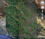
My KLM file has all the FHL Training Areas that are sometimes open to hunting. See the attached screen save. While in Google Earth with my KLM file, if you click on "Play" it will take you on a tour of FHL, zooming into the Training Areas one at a time, zooming out, and then move over to the next Training Area in numerical order. Each Training Area can be turned On or Off for individual study. The Google Earth Camera can be raised and tilted for flyby views of the terrain.
I don't use a laptop in the field, but I use it to study the terrain and foliage that I plan to hunt the following weekend. Nice to know what is on the other side of the hill when following tracks.
The Handout Maps are given to us when we register to hunt at FHL, plus scanned copies of the handout maps are available here on Jesses Forum. The Army draws a good map, so the Handout Maps are dead-nuts. That, plus my previous mapping experience in the Army, gave me a head start on the Google Earth stuff. I did my 12 month in Nam.
map, will do so. thanks
i have a active duty ID and stickers on the truck so they looked @ the ID s and told me where the shack was. so i also noticed it has stores too. things to keep wifey busy. any plans to be there soon again
I miss spoke. Forget about me being there this weekend. Well, unless I can find the registration for my Jeep before the weekend is over. Motor Vehicles wont be open until Monday, either, for me to get a temporary permit. I have the blue sticker on the license plate, but the paper work blew away. Last weekend I almost didn't get through the gate with my camper truck, because my insurance card had an expired date. Luckily, it was Friday afternoon and the guard called my insurance company to verify that I had insurance.
Lesson learned: Make sure you have everything up to date before attempting to get into that place. I wouldn't want to drive all the way up here from San Diego just to get turned away at the gate because of out dated paper work.
This site uses cookies to help personalise content, tailor your experience and to keep you logged in if you register.
By continuing to use this site, you are consenting to our use of cookies.