Shane
Well-known member
- Joined
- Nov 13, 2001
- Messages
- 940
- Reaction score
- 1
Something I thought about this year while looking around for old sheds and seeing some dandy bucks. I reallized that I would have a tough time remembering all of the locations I wanted to check out come spring.
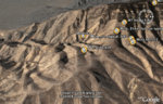
What if you could record locations of bucks and bulls as you see them while out in the field scouting and hunting in hopes of coming back in the spring to search for sheds near the locations animals were spotted?
Google Earth has a 'Placemark' (looks like a push pin) feature that allows you to place geographic markers on the map tiles. It records long/lat coordinates, allows you to label, and add notes.
Entering the day's sightings is something you can do while sipping on a beverage at the end of each day back at camp. Make a good visual journal if nothing else. Give it a try and report back!
[attachment=35931:attachment]
~ Shane