Okay, the Christmas Season is over, so I'll see you guys next year with more Google Earth files. For the guys who for one reason or another didn't ask to have the Fort Hunter Liggett Google file sent to them, they can still down load it free from the Yahoo Ozi Users forum. There is no guarantee against a malicious virus at a public forum like that, so the file should be scanned before using it.
TIP, at the bottom of the large menu strip located on left side of the Google Earth Screen you can click "Play" and it will take you on a tour of FHL stopping momentary at each Training Area.
Tip 2, You will probably have to join the OziExplorer User Group on Yahoo in order to down load the file. The longer you wait, the more chance there is for someone to modifiy the boundaries, or something.
Map maker ,
I am a newbie on the forum and planning on doing a trip to FHL since i cant afford my trip to Tejon anymore.
If i could get a copy of your map as well it would be greatly appreciated.
Thanks
Avo
Google Earth is a free download, and from then on the detail that you see will depend on your Graphic Card. My boy's workstation shows detail a lot better than this old Pentium 3 laptop with no graphic card.
Here is the link for the free down load:
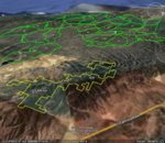
Attached is a perspective view made with Google Earth and this old computer showing the BLM at the San Lucas grade, and FHL in the background. I was able to add quite a bit onto the well known BLM parcel by researching the free GIS data bases available on the intenet. GIS adds a new dimension to hunting maps, and opens thousands of acres to hunting. Note that some of it is Indian land, and the perspective view doesn't show the boundaries.
This site uses cookies to help personalise content, tailor your experience and to keep you logged in if you register.
By continuing to use this site, you are consenting to our use of cookies.