
Navigation
Install the app
More options
You are using an out of date browser. It may not display this or other websites correctly.
You should upgrade or use an alternative browser.
You should upgrade or use an alternative browser.
- Thread starter ksberry209
- Start date
I also took a look at WRR on Thursday. Brush was too thick for good hunting, although I'm certainly no expert.
I'm heading to Lake Sonoma on Wednesday with my bow. I'm hoping the shotgun hunters have caused the piggies to move to the bow only areas.
John
I'm heading to Lake Sonoma on Wednesday with my bow. I'm hoping the shotgun hunters have caused the piggies to move to the bow only areas.
John
ksberry209
Well-known member
- Joined
- Oct 28, 2006
- Messages
- 498
- Reaction score
- 40
Hey Dave - How did you do? What was the terrain like further back?
Hello All
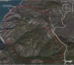
Here is the update on Walker Ridge area.
We arrived at 5:38 AM and drove eight miles up Walker Ridge Rd to the split off. The west split goes to the lake and Walker Ridge RD continues north to the right. There was little snow and a 2WD will make it through fine. We pulled off when we saw the first pond on the right. The word thick does not do the area justice. It was THICK, and there was few areas to glass from. We hiked up a side trial that led down towards the east towards Bear Valley for about two miles. We saw fresh pig tracks and yote's tracks but no pigs. I found a side trail and ventured into the thick stuff for awhile until I found a spring, but there was no signs other then racoon's.
I crossed Walker Ridge RD and worked a canyon as best I could but the brush was to thick to get down into it without belly crawling(which I did my fair share) But no luck. We checked the second watering hole but there was only two day old tracks there.
When we got back to the trail two guys on dirt bikes pulled up and told us that they had scared a small group of pigs off the trail past our rig about 20 minutes earlier. So we went back and found the pig tracks but it was just to thick for us to follow. We went back to the rig around 10:00 AM and drove north along Walker Ridge RD until we saw a camp ground area on the left. We had some lunch and then drove north until we hit Bear Valley RD and headed down into the Valley. The snow was almost gone, but lots of mud puddles to play in.
We stopped at the first ranch on the left and spoke to the rancher there. He advised that he sees pigs down near the base of the ridge each morning, but has not heard of anyone getting one without dogs in awhile. There also was no Pig Hunting signs hung anywhere along the way back to HWY 20 from Bear Valley. Real beautiful country up there.
Overall it was a great trip. The fresh tracks from the pigs that the two guys scared off makes me want to go back. Very thick and few open areas. I took some pictures which I hope to get up here as soon as I can find my USB cord.
I would go back to try again, Though I would work the northern end instead of the middle as it was just to thick. There were no ticks at all.
Dave
Speckmisser
Well-known member
- Joined
- Mar 12, 2001
- Messages
- 12,900
- Reaction score
- 27
Good write-up!
If you guys are finding tracks, then persistence will pay off. Kinda funny, but par for the course that the pigs would be out in the trail while you guys were hiking the other direction!
Good luck, and I'm looking forward to a success story soon.
If you guys are finding tracks, then persistence will pay off. Kinda funny, but par for the course that the pigs would be out in the trail while you guys were hiking the other direction!
Good luck, and I'm looking forward to a success story soon.
ksberry209
Well-known member
- Joined
- Oct 28, 2006
- Messages
- 498
- Reaction score
- 40
Dave - What program did you use for the pictures? Great details!!

ksberry209
Well-known member
- Joined
- Oct 28, 2006
- Messages
- 498
- Reaction score
- 40
Yeah I guess I deserve that. I meant what to use to draw the lines and edit the pictures or does google do that too?????
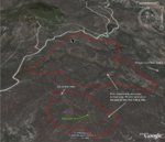
Sorry 2nd map was east side of Walker ridge RD. my bad

 Yeah its Google Earth. I bought a bunch of maps from a rancher up there and edited them with his information, The information was also cross confirmed with a packet I got for $30 at the Sportsman Expo last month of that area. I just added a KML creation tool to add the information to Google Earth. I have a few BLM maps also that I have imported into Google earth also.
Dave
Dave
JaegerMeister
Well-known member
- Joined
- Oct 12, 2007
- Messages
- 235
- Reaction score
- 7
<div class='quotetop'>QUOTE (Kentuck @ Feb 7 2008, 01:01 PM) <{POST_SNAPBACK}></div>
Do you happen to still have the ranchers contact info/ name of the ranch etc. I'd be interested in doing a hunt like that.
Thanks,
JaegerMeister
Traffic on Walker Ridge just went up 50%! HA! Just joking. I've poked around a little in that area myself. Talked to a rancher a few years ago down in Bear Valley that charged a tresspass fee for weekends. Could camp on his place and they would point you in the direction where they'd seen the most recent sign. I think he had 9000 acres.[/b]
Do you happen to still have the ranchers contact info/ name of the ranch etc. I'd be interested in doing a hunt like that.
Thanks,
JaegerMeister

<div class='quotetop'>QUOTE (Davidw100 @ Feb 12 2008, 05:31 PM) <{POST_SNAPBACK}></div>
Hey Davidw100, I am also from NorCal and new to this site, would you happen to want to share those BLM maps for google earth?
Sorry 2nd map was east side of Walker ridge RD. my badYeah its Google Earth. I bought a bunch of maps from a rancher up there and edited them with his information, The information was also cross confirmed with a packet I got for $30 at the Sportsman Expo last month of that area. I just added a KML creation tool to add the information to Google Earth. I have a few BLM maps also that I have imported into Google earth also.
Dave[/b]
Hey Davidw100, I am also from NorCal and new to this site, would you happen to want to share those BLM maps for google earth?
QRCode
