map
Well-known member
- Joined
- Jan 24, 2007
- Messages
- 2,098
- Reaction score
- 33
mr_eisma,
I received your Comment, but I don’t know how to use that forum feature. At the bottom of my Profile is my Private email. If you click that one I will receive a private email from you. Then I will reply with a small KML file attached.
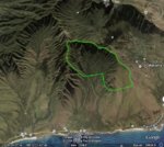
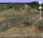
The hunting area boundary that I have made up is Ahupuaa O Kanana State Park for Google Earth. My wife and I were planning on hiking there, so I have it ready to send to you. After receiving it, all you have to do is “Open” the little file that I send using the File Menu and it will fly over to Kahana Bay and zoom-in to Hunting Area “C”. When exiting Google Earth click on “Yes” to make it part of the program. Otherwise, you will have to load each time.
If that KLM file will work with your software I will work on some of the others. By the way, if any other JHO’ers want to try Kahana with Google Earth send my an email.
Richard
I received your Comment, but I don’t know how to use that forum feature. At the bottom of my Profile is my Private email. If you click that one I will receive a private email from you. Then I will reply with a small KML file attached.
The hunting area boundary that I have made up is Ahupuaa O Kanana State Park for Google Earth. My wife and I were planning on hiking there, so I have it ready to send to you. After receiving it, all you have to do is “Open” the little file that I send using the File Menu and it will fly over to Kahana Bay and zoom-in to Hunting Area “C”. When exiting Google Earth click on “Yes” to make it part of the program. Otherwise, you will have to load each time.
If that KLM file will work with your software I will work on some of the others. By the way, if any other JHO’ers want to try Kahana with Google Earth send my an email.
Richard